452229-1 SWRS - Districtwide Rumble Stripes Bundle 5A
Project Details
About
The Florida Department of Transportation (FDOT) is enhancing safety on key state roads in Brevard, Orange, and Seminole counties by adding rumble striping to the center and outer lines of travel lanes. Rumble stripes are repeating clusters of narrow, shallow grooves carved into the roadway surface, typically along the centerline or edge lines of the road. This ridged texture generates a distinct vibration and a low-pitched rumbling noise when driven over, alerting drivers if their vehicle veers out of its lane. The installation of rumble striping helps with reducing roadway departure crashes caused by inattentive drivers and increases the visibility of pavement edges at night or during bad weather.
These improvements will be made on roads with speed limits of 50 mph or higher that have even shoulders and lack existing auditory or vibratory pavement markings. The roadways included in this project are:
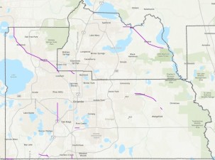
Brevard County
- U.S. 1:
- From south of East University Boulevard to the Indian River County line
- From south of Cheney Highway (S.R. 50) to Miller Cove Road
- From south of Cuyler Street to south of Oak Grove Road
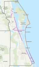
- S.R. A1A:
- A 2,000-foot-long section east of the S.R. 401 interchange
- From Coconut Point Park to Sebastian Inlet North
- S.R. 405:
- From north of Foley Road to east of Angela Lane
- S.R. 520:
- From west of I-95 to east of S.R. A1A
- S.R. 524:
- From north of S.R. 520 to London Boulevard
Orange County
- S.R. 500/U.S. 441:
- From the Orange County line to north of Maitland Boulevard (S.R. 414)
- From south of Hunters Creek Boulevard to the Osceola County line
- S.R. 414:
- From Forest City Road (S.R. 434) to the I-4 Interchange
- S.R. 50:
- From east of North Avalon Park Boulevard to the S.R. 520 Interchange
- S.R. 520:
- From Macon Parkway to Maxim Parkway
- S.R. 435:
- From north of Westgate Drive to the I-4 Interchange
- S.R. 482:
- From west of Horizon Park Drive to west of Sunport Drive
- S.R. 530:
- From the Osceola County line to west of S.R. 429
- S.R. 536:
- From west of the I-4 Interchange to Apopka-Vineland Road
- S.R. 435:
- From south of Lake Bryan Beach Boulevard to International Drive South
Seminole County
- S.R. 46:
- From east of East Lake Mary Boulevard to east of Rest Haven Road
- S.R. 500/U.S. 441:
- From east of the Orange County line to Palm Avenue
- S.R. 15/600:
- From the I-4 Interchange to Monroe Road
Contact Information
| Communications Team |
|---|
|
Ryan Yglesias
(407) 278-2713
Ryan.Yglesias@dot.state.fl.us
|
| For Media Inquiries Only |
|
FDOT-D5Comm@dot.state.fl.us
|
Lane Closures
- There are no lane closures at this time.